

PILGRIMAGE OF MADHYA PRADESH
Sanchi:
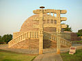
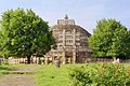
Sanchi is a small village in Raisen District of the State of Madhya Pradesh, India, it is located 46 km north east of Bhopal, and 10 km from Besnagar and Vidisha in the central part of the state of Madhya Pradesh. It is the location of several Buddhist monuments dating from the third century BCE to the twelfth century CE and is one of the important places of Buddhist pilgrimage. It is a nagar panchayat in Raisen district in the Indian state of Madhya Pradesh. Toranas surround the Stupa and they each represent love, peace, trust, and courage.
The 'Great Stupa' at Sanchi was originally commissioned by the emperor Ashoka the Great in the third century BCE. Its nucleus was a simple hemispherical brick structure built over the relics of the Buddha. It was crowned by the chatra, a parasol-like structure symbolising high rank, which was intended to honour and shelter the relics.
Gallery:
 Stupa no. 3, Sanchi. |
 Sanchi, 2003. |
 Details of Northern Gate, Sanchi Stupa built in 3rd century BC. |
 Stupa of Buddha's Disciple, Sanchi. |
 Design of the 'Great Stupa' at Sanchi. |
 Sanchi Stupa, with restored garden 2009. |
 A buddhist monastery at Sanchi. |
 Monks visiting the |
Khajuraho:
The most famous architectural style of Khajuraho temples is one of his own kind. The temples are built from east to west and have three main compartments- the entrance (ardha mandapa), assembly hall (mandapa) and an inner sanctum (garbhagriha). The temples are divided into three geographical groups: Western, eastern and southern. The western group is the most famous and the most typical of the Khajuraho temples. Kandariya Mahadeo is the main temple here. The shrine has an exquisitely carved entrance arch with a multitude of themes celestial beings, lovers, serenading museums- movements captured in stone and frozen in time, yet retaining the warmth of pulsating life. The stone seems to have taken on the sensuousness of the carved figures. The oldest surviving shrine is the Chaunsat Yogini. One of the three granite temples, this one is dedicated to Godess Kali but the image has not survived. The Chitragupta Temple is dedicated to Sun God. A seven-horsed chariot drives the imposing five feet idol. The Vishwanath temple has an impressive three-headed image of Lord Brahma. The exteriors are profusely carved and facing the shrine is a Nandi temple with a massive 6 ft high Nandi Bull. There are few Vaishnavite temples like those of Lakshmana and Varaha temples. Eastern group consists of Jain and Hindu temples mainly. The sculptures on the northern outer wall makes Parsavanath temple finest in the group. The carvings are timeless, of a women bending thoughtfully over a letter, a damsel removing a thorn from her foot. The other Jain temples are Ghantai, Adinath temple. This group also has three Hindu temple- Brahma, Vamana and Javari temples. Southern group of temples are five kms from the Khajoraho village. Chaturbhuj temple has a massive, intricately carved image of Vishnu. Duladeo temple is dedicated to Lord Shiva.
Deogarh:
13 km from Jakhlaun railway station on the Jhansi-babina Passenger train route, is situated the fort of the God, Deogarh. It is on the right bank of the Betwa River at the western end of the Lalitpur range of hills. The fort is entered though a corbelled gateway in the outer wall. A path has been cleared through the undergrowth and broken statuary lies scattered about. Within the fort is a remarkable group of 31 Jain Temples. The site was a Jain center from the 8th to the 17th centuries. Within the temples are panels depicting scenes from Jain mythology, tirthankara images, Manasthamba or votive pillars, Ayagpattas or votive tablets, Sarvatobhadra Pratima's or Jain images visible from all sides and Sahasrakuta's or pillars carved with a thousand Jin figures. Most important among the group are temples No.11 and 12, the Santinath temple. Among other important structures at deogarh are the Varah temple, the rock cut cave-Siddha-ki-Gufa, Rajghati and the Naharghati. The jewel of Deogarh, however is in a field by a well close to the banks of the Betwa. This is the Dashavatar Temple dedicated to Lord Vishnu. It belongs to the Gupta period and is dated to about the 6th century AD. It is the earliest known Panchayatan temple of north India. It bears an inscription attributable to Govinda, Viceroy of Malwa and brother of the great Kumaragupta I. A row of superbly sculpted panels adorns the terraced basement which rises above the high plinth of the temple. A doorway with intricately carved figures of Ganga and Yamuna leads to the garbhagriha or sanctum sanctorum. The temple is particularly well known for its Rathika panels in recesses along its three sidewalls. These fine stone reliefs depict scenes from Vaishnava mythology, and are identified as the Gajendra Moksh panel, Nar-Narayan Tapasya and the Anantasayi Vishnu. Only the lower portion remains of the shikhar, once the most important part of the temple. The gupta age, because of its superb sculptures, is "in the annals of classical India almost what the Periclean age is in the history of Greece". The beauty of the images at Deogarh carved out of granite and red or gray sandstone bear testimony to this. The nearest Airport is at Gwalior, which is 235 km to Deogarh. The nearest railway station is Jakhlaun is about 13 km and another station is Lalitpur, which is 23 km away for Deogarh. It is connected with bus services to all important centers in the region. Some of the major road distances are: Jhansi 123 km, Katia 147km, Lalitpur- 23km, Matatila- 93km.
Omkareshwar:
Omkareshwar is one of the Jyotirlingam at the Siva temple of Shri Omkar Mandhata, among the twelve jyotirlingam in India. It is situated at the confluence of the Narmada and Kaveri rivers. Though this island has foliage of Hindu and Jain temples, another extravagant sight is the Siddhnath temple, which is a marvel of early medieval architecture. The island temple presents a very picturesque sight and are well worth visiting. Accommodation can be sought in many Dharamshalas and Holkar Guest House. There are local buses for Omkareshwar from Indore, Ujjain, Khandwa. OmkareshwarRoad, on Ratlam-Indore- Khandwa line, is the nearest railway station. Omkareshwar itself is 12 km from here by road.
Amarkantak:
Amarkantak (Devanagari: अमरकंटक) is a pilgrim town and a nagar panchayat in Anuppur District in the state of Madhya Pradesh, India. Also called "Teerthraj" (the king of pilgrimages), Amarkantak region is a unique natural heritage area and is the meeting point of the Vindhyas and the Satpuras, with the Maikal HillsNarmada River, the Sone River and Johila River emerge. being the fulcrum. This is where the
Location:
Amarkantak is situated in [ [Madhya Pradesh] in India. Amarkantak is located at 22°40′N 81°45′E / 22.67°N 81.75°E. It has an average elevation of 1048 metres (3438 ft). Roads running through Rewa, Shahdol, Anuppur, Bilaspur, Jabalpur, Katni and Pendra connect it. The nearest railway stations are AnuppurPendra Road (43 km)via keonchi and only 28 k.m. via Jwaleshwar. in Chhatisgarh. The nearest Airport is Dumna Jabalpur (240 km), Raipur C.G. (2 and 40 km).

Places of tourist importance:
Amarkantak being a unique natural heritage is very rich in biodiversity. It has got a number of places of scenic beauty. Apart from this it is source of origin of three important rivers. It is a great pilgrim center for Hindus. It is thus a great-unexplored tourism destination.
Narmadakund and temples:
At the place of origin of Narmada River there is an open pool known as Narmadakund. Around this kund there are number of temples such as Narmada and Shiva temple, Kartikey temple, Shri Ram Janki temple, Annapurna temple, Guru Gorakhnath temple, Sri Shuryanarayan temple, Vangeshwar Mahadev temple, Durga temple, Shiv Pariwar, Siddheswar Mahadev temple, Sri Radha Krishna temple, Eleven Rudra temple etc.
Ancient temples of Kalachuri period:
The ancient temples of Kalachuri period are situated in the south of Narmadakund just behind it. These were built by Kalachuri Maharaja Karnadeva (1042-1072 AD). The Machhendranath and Pataleshwar temples are excellent examples of architecture. There is also Keshav Narayan temple built by the Bhonsle ruler of Nagpur in the 18th century.
Sonemuda:
Sonemuda is the place of origin of Sone River. It is situated at a distance of 1.5 km from Narmadakund at the very edge of Maikal Mountain. The Sone River cascades from the mountain in a waterfall hundreds of feet long. From the viewing platform facing east, there is a panorama of forested hills and valleys. According to Megasthanes and other Aryan writers the river Sone gets its name from gold as gold dust is found in the water of Sone.
Mai ki Bagiya (Goddess garden):
A grove of trees in dense forests situated at a distance of one km from Narmadakund is named “Mai ki Bagiya” in honour of the goddess Narmada. In this natural garden there are Mango, Banana and other fruit trees along with Gulbakavli, roses and other flower plants.
Kapildhara (Kapil waterfall):
Six km northwest of Narmadakund is the Kapildhara waterfall with a fall of about hundred feet. According to scriptures, Kapil Muni lived here. There is a scene of natural beauty with mountains and dense forest down hills. According to ‘Vindhya Vaibhav’ Kapil Muni performed severe austerities here and received divine light. He also wrote ‘sankhya philosophy’ (an advanced treatise on mathematics) at this place. The Kapileshwar temple is also situated nearby. The surrounding mountains are full of caves where saints have been performing their spiritual practices.
Kabir chabutra (the platform of saint Kabir):
It is an old belief that the great saint Kabir performed austerities here and achieved spiritual powers. It is therefore a holy place for the Kabir panth sect. The local people, the Panikas, consider Kabir Chabutara as one of the holiest places of the Kabirpanthis because Sant Kabir spent many years here in meditation.At this very place Kabir and Nanak met and discussed spiritual matters and introduced the way of better living for human being. It is also the meeting point of three districts, Anuppur and Dindori districts of Madhya Pradesh and Bilaspur district of Chhatisgarh. There is also a Kabir waterfall here.
Shri Jwaleshwar Mahadev (the temple of Shiva):
The Jwaleshwar temple and the source of origin of the third river Juhila River is situated at a distance of 8 km from Amarkantak on Shahdol road. According to ‘Vindhya Vaibhav’ Lord Shiva himself established a Shivling here and also scattered crores of other Shivlings over Maikal Mountain. According to puranic traditions a rectangular area containing crores of Shivlings is known as ‘Maha Rudra Meru’ and is the abode of lord Shiva himself. There are only two ‘Maha Rudra Meru’ places Varanasi and Amarkantak. Lord Shiva and Parvati live here because of this special spiritual quality.
Muktagiri:
Muktagiri is a Jain Pilgrimage centre, located on border of Madhya Pradesh and Maharashtra in India. It comes under Bhainsdehi tehsil of Betul district or Baitul district in Madhya Pradesh, India. It is 14 km away from Paratwada, Dist. Amravati ,Maharashtra. Muktagiri is 7 km away from Kharpi village on Paratwada - Baitul road.
Muktagiri is also called as 'Mendhagiri'. There are 52 temples on the mountain, surrounding a beautiful waterfall. The waterfall is generally visible only when there is enough rainfall in the area. One can plan trip to Muktagiri between June to September to see the waterfall. A lot of monkeys can be seen near the 10th Temple - Bhagwan Sheetalnath temple - near which the waterfall is located. The 10th Temple is an ancient temple and is inside an ancient cave. The cave is prone to stonefall (which is generally said to happen only during night). Also, lot of honeybees are at a large distance from the cave. The 1st Temple, 10th Temple, 26th Temple and 40th Temple are the main temples.
Temple Timings:
The temples close at around 11 am. Since the temples are in Satpura Mountain range and surrounded by jungle, it is better to visit the temples before 10 am. It takes around 1.25 to 1.5 hour for an average person to finish the entire upward and downward journeys and also little bit of puja in each temple. After 11am, one can not go inside the temples. One has to greet the Bhagwans from outside the door of each temple.
Since the nearby area is a jungle, one has to come down before noon or before it becomes dark. There are separate routes for upward and downward journeys. The temples are jagrut or holy and divine temples. So one should not carry out any bad acts in or around the temples.
Directions:
While traversing the route of temples, one should look at the footsteps since the route from 1st to 52nd temple is written in orange colour on the footsteps since the 52 temples are divided in 4 or 5 groups and are located in different areas of the mountain. But they are not very far from each other. The entry passage to some of the temples is very narrow. In some passages and on some of the steps especially inside the temples which are inside other temples, taller people have to crawl. Also, very fat people may not be able to traverse these passages.
The way to 51st & 52nd Temple is from inside 50th Temple. This inside route is quite dark. There are no lights in this inner passage. So it is better to carry a torch along. The downward journey route is also from 52nd Temple only. So without a torch or a guide, one will not be able to come down / one will be lost.
Menu
News
tourism statistics
07/10/2009 21:01———
Blog
Do's and Don'ts of Travel
07/10/2009 21:08———
 |